In September 2017, I went on a week-long adventure in the wonderful subarctic country of Iceland.
Iceland had captivated my imagination since spring 2011, when I watched a documentary called Heima about the Icelandic band Sigur Rós. I was particularly drawn to the footage of Iceland’s many stunning landscapes. The demands of graduate student life would keep me from visiting for years, and in the meantime my growing interest in photography and hiking only intensified my desire to visit.
Route 1, also known as the Ring Road, circles much of the island and provides a convenient way of exploring many of Iceland’s diverse landscapes. The southern part of the country offers waterfalls and beaches, as well as the famous Eyjafjallajökull volcano. The name of this volcano was the answer to a trivia question once. The names of pretty much everywhere in Iceland are as unpronounceable as this one. Can’t say that we nailed the trivia question either.
Heading east, one encounters the Jökulsárlón glacier lagoon and the East Fjords. Towards the north there is Lake Mývatn, where there are many hot springs and geysers. The West Fjords are on a peninsula northwest of the Ring Road, and the Snæfellsjökull volcano is on another to the west. I chose to take the entire Ring Road counterclockwise from Reykjavík, with a few departures from the Ring Road to explore Seyðisfjörður, Hvammstangi, and Snæfellsjökull.
A hot spring near Mývatn.

Map showing various points of interest on my trip.
I flew out of Baltimore on Friday September 8th, and returned a week later on the 15th. Here is a brief outline of the trip:
Day 1: BWI -> KEF -> Reykjavík -> Seljalandsfoss -> Eyjafjallajökull -> Skogafoss -> Hvolsvöllur
Day 2: Hvolsvöllur -> Reynisfjara Beach -> Skaftafell -> Jökulsárlón -> Höfn
Day 3: Höfn -> Egilsstaðir -> Seyðisfjörður -> Egilsstaðir
Day 4: Egilsstaðir -> Namaskard -> Myvatn -> Hverfjall -> Goðafoss -> Akureyri
Day 5: Akureyri -> Hvammstangi -> Borgarnes
Day 6: Borgarnes -> Gatklettur -> Hellnar -> Snæfellsjökull -> Reykjavík
Day 7: Reykjavík -> KEF -> BWI
Day 1: Reykjavík and the southern coast
Sat. 9 September, 2017

Sunrise just outside of Keflavik International Airport.
My plane landed at Keflavik International Airport early in the morning. The sun was rising above the horizon just as I exited the terminal on my way to pick up my silver Suzuki Vitara, which would be my sole means of transportation during my week around the country. Even the drive from the airport to Reykjavík was breathtakingly beautiful, with fog and steam spreading across a landscape littered with moss and patches of vegetation.

Views of Reykjavík in the morning.
One thing about traveling to Iceland is that a lot of the gas stations in the remote areas are unattended. Conveniently, American credit cards don’t have PINs, which means you get to buy a prepaid gas card. So basically, I had to guesstimate the gas mileage of my car based on how much gas I used between the airport and the gas station, and then estimate the amount of fuel I would need for the trip, in these funny units called “litres,” and then convert that to how much money in Icelandic króna I would need to put on my card. At 7am. After having not slept at all on my flight. (My guess ended up being almost spot on. Thank you, American education system.)
I found some free parking on Brávallagata/Hringbraut (Rt. 49) and wandered around town. The streets were very quiet and there was a mix of older and more modern houses. My trek ended at Hallgrimskirkja, one of Reykjavík’s iconic landmarks and the largest church in Iceland. After warming up with some soup from the nearby Café Loki, I set out on my first leg of the day’s trip eastward.

Top: Hallgrimskirkja, Left: Skólavörðustígur, Right: Loki Guesthouse near Café Loki.
My first stop was at Seljalandsfoss, just under two hours southeast of Reykjavík. Despite having arrived in Iceland towards the end of the tourist season, I encountered many tourists throughout much of my trip. Fortunately, I was able to get some shots with only a couple of people in them.

Seljalandsfoss from front and behind.
By the time I left Seljalandsfoss, I had not slept in over thirty hours and was utterly exhausted. I ended up sleeping for a couple of hours at a rest stop and grabbing some coffee, before my Airbnb host Jórunn kindly let me check in early so that I could sleep for another two hours. I stayed in a bedroom in their farmhouse near Hvolsvöllur.

The view from a dirt road near my Airbnb.
After a refreshing nap, I headed out to Skógafoss, another popular waterfall. Though I could not hike as far as I’d wanted due to my sleeping for four hours, based on a topographical map I estimate that I still gained 1,700ft in elevation. So not a bad hike overall. The views were gorgeous, with moss and grass covering a treeless landscape and waterfalls cutting through the ground, exposing giant walls of bedrock. The cliffs made for some exciting hiking, and amazingly I was just one of a handful of people. I made my way back down to the base of the waterfall around sunset for dinner and a beer at Hótel Skógafoss, and then passed out in my Airbnb.

Left: Skógafoss (notice the sheep on the slopes), Center: gorges upstream, Right: another waterfall upstream.

Overlooking Skógafoss at the beginning of my hike.
Day 2: Coastlines and Glaciers
Sun. 10 September, 2017
I woke up well rested to breakfast prepared by my host Jórunn, who helpfully provided an overview of the various [reproductive] animal husbandry practices that I probably need not go into here. She had had a fairly extensive guestbook, having hosted visitors from all over the world (apparently, I was her first visitor of Japanese heritage though). After checking out, I headed eastward to Reynisfjara beach. The sand was black and unlike anything I’d seen at a beach before.

Beautiful rock formations along the coast.

The Ring Road is full of places to pull over and admire the nature.
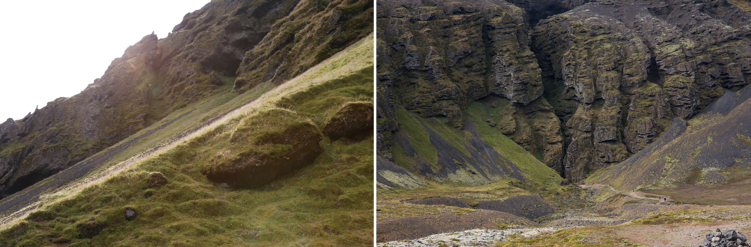
Skaftafell National Park was a two-hour trip east of Reynisfjara beach. It is home to the Skaftafellsjökull glacier, which is a part of the Vatnajökull ice cap, the largest in Europe by volume.

En route to Skaftafell.

Top: mountains in the distance spotted en route to Skaftafell, Bottom/Right: Skaftafell National Park.

The Skaftafellsjökull glacier.
I ended up hiking around the area for a few hours. The park itself is huge and one could probably spend weeks exploring it, but I had to cut this visit short for a near-sunset shoot at my next destination, the Jökulsárlón glacier lagoon. The lagoon was crowded with tourists and photographers when I got there, so I spent a half hour scouting for good views, set up my tripod, and started shooting away. I was rewarded with this shot, an aluminum print of which now sits above my dining table.

Icebergs in the Jökulsárlón glacier lagoon, with Vatnajökull in the background.
That night I stayed in a guesthouse in the quiet fishing town of Höfn. I managed to capture a shot of some distant mountains on the other side of the water.

Top: view from a cliff in Höfn, Bottom: dinner at Pakkhus Restaurant.
Day 3: Highlands and Fjords
Mon. 11 September, 2017
My next leg of the trip started as a sunny day with beautiful views of the ocean and cliffs to my right, and steep cliffs and mountains on my left.

Left: landscape along the coastline of Iceland, Right: a street sign (notice the NASA sticker!).
I soon left behind the rocky coastline for the East Fjords, which afforded spectacular views. The roads turned to dirt, and I found myself driving nervously on some steep winding roads. Eventually one reaches the highlands, and from there it is a straight shot (through one of the few wooded areas I encountered in Iceland) to Egilsstaðir.

East Fjords
Egilsstaðir was another small town (as most towns in Iceland are, it turns out), and one could probably explore the entire town on foot in an afternoon. It was especially interesting to see so many tourists in such a small town. It’s about as bizarre as seeing tourists from around the world flocking to my hometown of about 1,000 people. Imagine that.

Top: Café Nielsen, Bottom: Egilsstaðir.
After grabbing some lunch at Café Nielsen, I traveled eastward off of the Ring Road toward Seyðisfjörður, a town at the bottom of a fjord. Originally, I wanted to visit Dalatangi, where there is an orange lighthouse that was featured in the cover photo of the Amiina album, The Lighthouse Project. However, that was all the way on the other side of the mountain, so I took a short trip here instead.

Left: Seyðisfjörður, Right: winding road from Egilsstaðir.

Seyðisfjörður
I loved watching the mountain tops scrape the low clouds, and the soft rays of sunlight bleeding through. As much as I wanted to admire the slopes and the waterfalls, the steep, winding roads demanded most of my attention. Like other towns that I visited in Iceland, Seyðisfjörður was small and very walkable. The downtown area (if you could call it that) had a variety of small shops and restaurants. I ended up ordering coffee from a French guy, who had found temporary work in Iceland. I returned to Egilsstaðir and dined at Café Nielsen for a second time. The food was delicious, though expensive (a recurring theme throughout this trip).

Left: Guesthouse Olga, where I stayed, Right: A house nearby.
Day 4: Hotsprings and the Northern Lights
Tue. 12 September, 2017
Having circled about halfway around the island, I next headed northwest toward the hot springs and geothermal vents near Mývatn. The sights were otherworldly; there were steamy vents, volcanic craters, turquoise lakes, and caves to explore. The air smelled of sulphur. I tried unsuccessfully to get a shot of what looked like steam coming out of a fellow tourist’s butt.

Geothermal vents near Mývatn.

Steam blowing out of a pile of rocks.

Blue Lake. There were many signs warning of the hot water and steam.
I stumbled upon a cave containing hot, blue water. Apparently, the locals used to bathe in it, but the water eventually became too hot.

Hot spring inside Grjótagjá cave.
Hverfjall is another worthwhile destination in the area. It is a dormant volcano, and the views from along the rim of the giant crater are well worth the hike.

Top Left: side view of the crater (see hikers on top for scale), Top Right: the crater, Bottom: views from the crater rim.
My main goal for the day was to visit Goðafoss, which is a very popular waterfall. I spent about an hour hiking around and scouting a good vantage point before setting up my tripod and capturing this shot.

Goðafoss illuminated by the low, cloud-covered sun.
I agonized over whether I should stay longer to capture a proper sunset at Goðafoss, but the clouds were not looking very promising and I decided to continue westward toward my next destination, the town of Akureyri. With some fortunate timing, I was able to get this shot of the setting sun’s red rays skimming the tips of these peaks nearby.

Mountains behind Akureyri around sunset.
Though I had not been planning on seeing the northern lights during this trip, a fellow traveler I met in Höfn suggested that I check the Aurora forecast every day. Most days there was very little activity, but on this night the forecast registered a 3 (moderate) out of 9, the highest I would see during this trip. So, after dinner I grabbed my camera and took a walk around town, periodically looking up at the night sky. I ended up in a dark park and decided to wait around for a while to see if anything would happen. After perhaps 30 minutes of waiting, I noticed something moving in the sky. It was a faint gray, and at first I thought it was just a cloud, but eventually the light transformed into a bright green dancing curtain of light! My first aurora! I was ecstatic.

Aurora Borealis in Akureyri.
I then heard a pop from above, as some flying object appeared seemingly out of nowhere and darted across the sky. I am unsure of what exactly I saw (I believe it might be classified as a meteor), but it broke into a couple of pieces before disappearing into the horizon.

Aurora Borealis, and a trail of the flying object.
Day 5: Borgarnes
Wed. 13 September, 2017
I decided to make a 2.5-hour trip to Hvammstangi first before embarking on the second, 1.5-hour leg to Borgarnes. Akureyri was surprisingly quiet in the morning considering it was a weekday. Shortly after I left the town, though, the sky started turning gray again.

The streets of Akureyri in the morning.

A stone monument somewhere between Akureyri and Hvammstangi.

Left: Sjávarborg Restaurant, Right: a seal from the Icelandic Seal Center in Hvammstangi.

View of Hvammstangi.
At some points between Hvammstangi and Borgarnes I had to drive through low clouds. The conditions improved dramatically as I descended from the highlands and the thinning clouds revealed the blue sky above. Along the way, I unexpectedly found a trail to hike by the roadside.

Left: what it looks like to drive through clouds, Right: photo from an unplanned hike shortly after going through the clouds.
The small town of Borgarnes was my last stop before I returned to Reykjavík. One of its main attractions is The Settlement Centre, which comprises a museum on Icelandic settlement and one about Egil’s Saga. The self-guided audio tours were actually quite substantial, and I ended up spending over two hours learning about Icelandic history. I spent much of the evening walking around and then, eventually, freezing my butt off trying to catch the northern lights again. I didn’t see any that night, but I did capture some long-exposure shots of the night sky (also, my butt fell off).

Left: my accommodations at Egils Kaupangur, Center: Borgarnes, Right: a mural with one of Egil’s poems.

Probably some milk thing I guess.

The night sky in Borgarnes.
Day 6: Snæfellsjökull Park and Reykjavík
Thu. 14 September, 2017
Before heading northwest toward Snæfellsjökull, I grabbed breakfast at a quirky coffee shop, where the elderly locals were just hanging out. There were couches, board games, and lots of art displayed across a few rooms. I definitely miss the cozy, small-town feel.

Blómasetrið - Kaffi Kyrrð, where I had carrot cake for breakfast.
Following my friend’s suggestion, I stopped by Rauðfeldsgjá Ravine on my way to Snæfellsjökull park. It is a giant crack in the wall, and apparently one can go fairly deep inside, but the place was surprisingly crowded with tourists so I gave up after about a half hour.
Left: slopes leading up to the crack, Right: Rauðfeldsgjá Ravine (see people on the trail for scale).
Gatklettur was full of beautiful views of the cliffs along the coastline. This area would make for some excellent sunrise/sunset photography, but I decided that I had more to see and that I would have to revisit during a future trip.

Left: Cliffs along the coastline, Right: A house with Snæfellsjökull in the background.

Hellnar church.
As I approached this dilapidated stone house, it dawned on me that I had seen a photo of this house many years ago (perhaps a decade ago!) and forgotten about it. Time and the elements apparently have not been kind to this structure; the orange roof visible in the older photo is completely gone.

Abandoned farmhouse near Snæfellsjökull.
Once in Snæfellsjökull park, I randomly chose a trail to explore. Evidently my choice was not very popular, because I encountered not one soul on this trail. I was, however, completely ignored by these chill creatures.

I was nothing but a leaf blowing by to these guys.
Though the tip of the mountain was obscured by clouds, Snæfellsjökull was still a breathtaking sight. It was well into the late afternoon by the time I finished this trail, so regrettably I had to end my adventures here to head to Reykjavík.

My rental car parked at the trail head. To see beyond the clouds, you can use your imagination. Or Google.
I traced my steps back to Borgarnes, and then took Rt. 1 south to Reykjavík. As I walked around looking for a good place to eat, I caught a glimpse of life in the Icelandic capital.

Laugavegur, a street with many shops and restaurants.
Apparently, Reykjavík is a great destination for graffiti and street art. Spray paintings and murals were prevalent in some corners and streets.

A graffiti-covered building in Reykjavík.

Corner of Barónsstígur and Njálsgata.

A cyclist going up a hill. Notice how the cars aren’t all parked facing the same direction…???
I eventually found a restaurant around Laugavegur, but I cannot remember its name. As is typical in Iceland, the food was delicious and ridiculously expensive. After enjoying my last dinner in Iceland, I walked a mile or so back to my hotel and passed out.
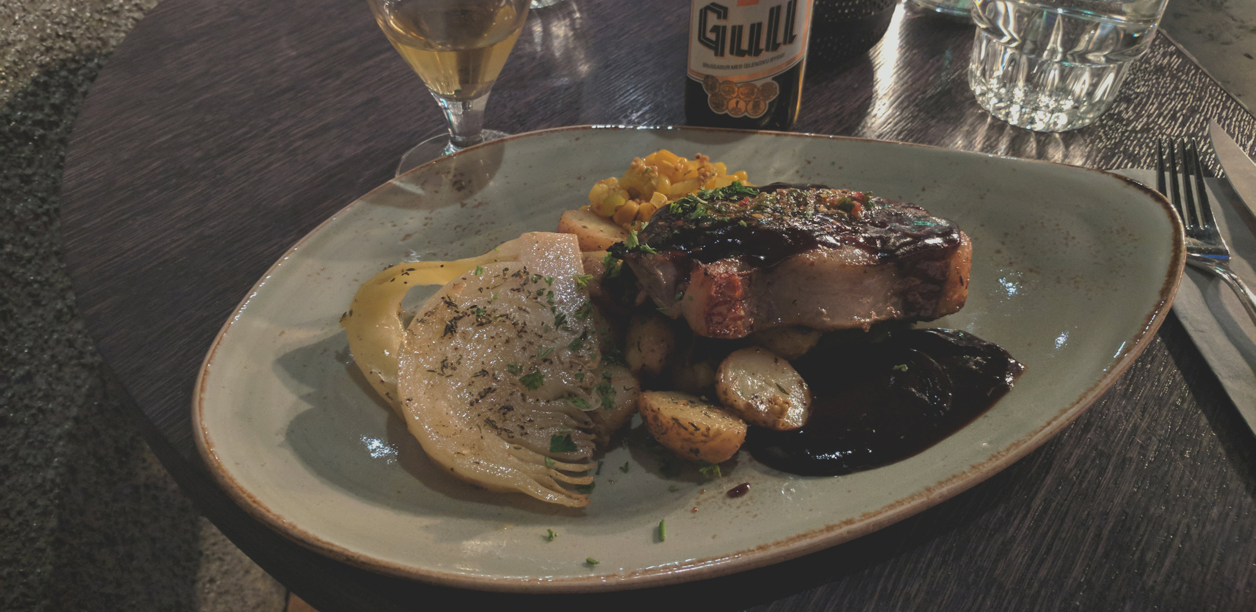
Lamb with vegetables and Gull beer.

Tiramisu for dessert.
Day 7: Goodbye Reykjavík
Fri. 15 September, 2017
After a week of running around Iceland, my solo trip was coming to an end. I took this last chance to explore the city a bit more before heading over to the airport to catch my flight home. I ended up finding parking near Reykjavík Central Apartments (on Google Maps, the lot is plainly labeled “Free Parking”) and walking along the waterfront.

The waterfront pedestrian path took me through a shipyard.
I actually got to see one of Iceland’s most feared modern destroyers. Just kidding. It was the flagship of the Icelandic Coast Guard, ICGV Thor. Iceland has no standing army, and is the most peaceful nation according to the Global Peace Index.
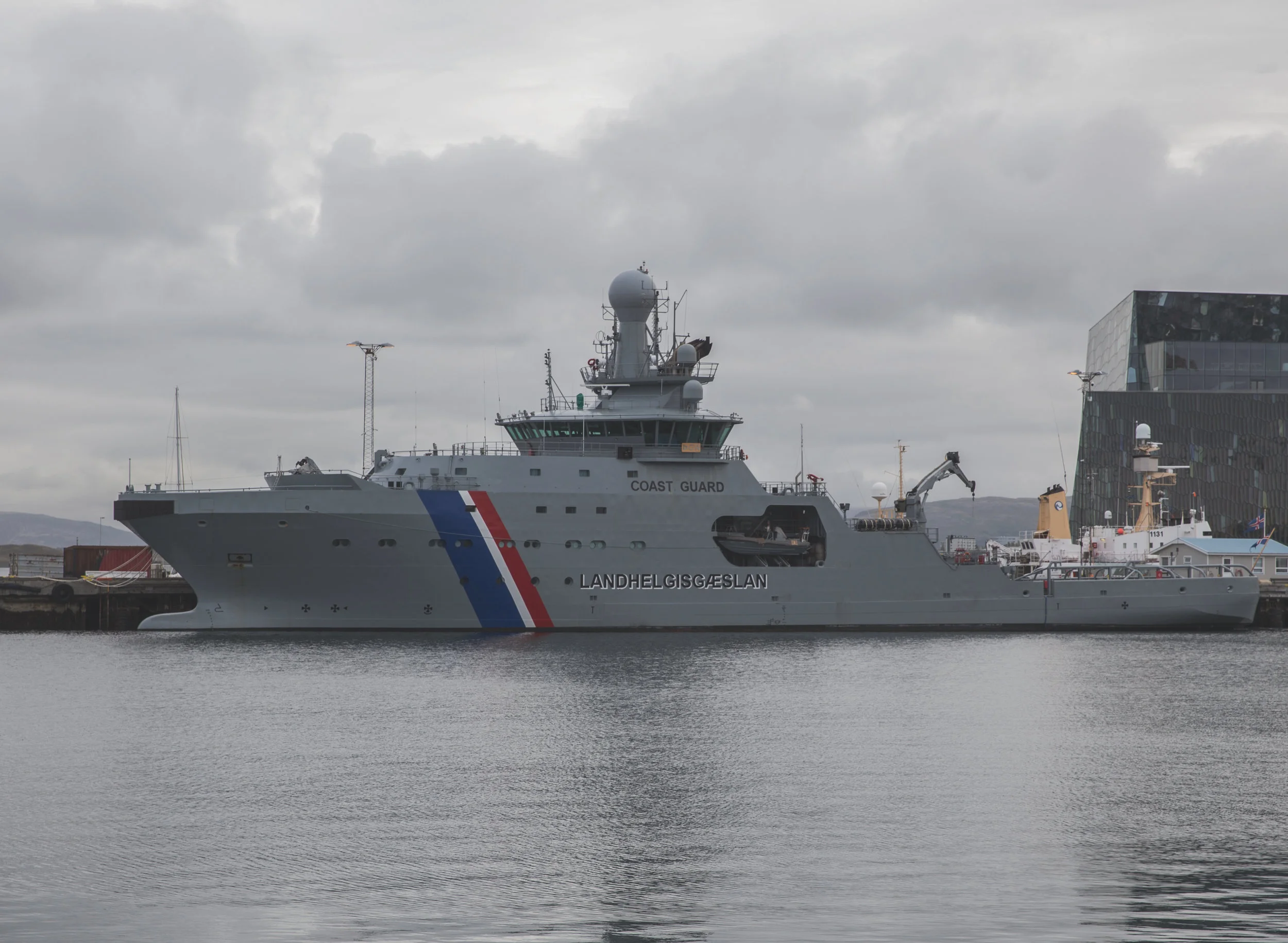
ICGV Thor.
Along the way I stopped by Harpa, which is a concert hall. It was a really modern, fancy building with underground parking and some gift shops. Perhaps on a future trip I will enjoy a performance by the Iceland Symphony Orchestra. Unfortunately, I could not catch any shows as my flight was leaving in the early afternoon. I did pay some money to use their bathroom, though.

Harpa.

Cellist sculpture in front of Harpa.
Although Reykjavík is a small city, it does have somewhat of a skyline. At times the city felt much larger to me than its population of under 130,000 would suggest.

Reykjavík from Rt. 41.
My morning in Reykjavík ended with a visit to the iconic sculpture, The Sun Voyager. As expected, the area was swarmed by like-minded tourists taking photos with the sculpture, so it took a bit of patience and positioning to capture this shot.

The Sun Voyager sculpture by Jón Gunnar Árnason.
I spent an incredible week touring Iceland and experiencing just a taste of what this beautiful country has to offer. This was also my first fully solo trip abroad and, as of this writing, probably the most fun I’ve had in a single week.
If I could visit again, I would definitely explore the west fjords and focus on one or two other areas. One hike that did not make it into my agenda this trip was Thórsmörk, which is a goldmine for landscape photography. I would also pursue some organized activities, such as glacier hikes and helicopter tours. This trip was like an initial scouting expedition, and I hope that there will be further adventures to come.